Version History
Here you can find the changelog of Navionics® Boating since it was posted on our website on 2016-09-28.
The latest version is 21.0.3 and it was updated on soft112.com on 25 April, 2024.
See below the changes in each version:
version 21.0.3
posted on 2024-04-23
Apr 23, 2024
Version 21.0.3
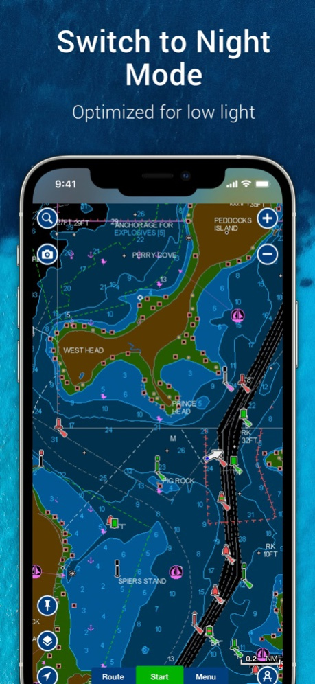
Night mode is here. With this update, you’ll be able to switch to a low light-optimized color palette that’s easier to see while on your boating and fishing adventures at night. Also, the menu appearance can turn dark based on your phone settings.
See you on the dark side.
version 21.0.2
posted on 2024-04-18
Apr 18, 2024
Version 21.0.2
Night mode is here. With this update, you’ll be able to switch to a low light-optimized color palette that’s easier to see while on your boating and fishing adventures at night. Also, the menu appearance can turn dark based on your phone settings.
See you on the dark side.
version 21.0.1
posted on 2024-04-17
Apr 17, 2024
Version 21.0.1
Night mode is here. With this update, you’ll be able to switch to a low light-optimized color palette that’s easier to see while on your boating and fishing adventures at night. Also, the menu appearance can turn dark based on your phone settings.
See you on the dark side.
version 20.1.2
posted on 2024-01-22
Jan 22, 2024
Version 20.1.2
This update includes enhancements to Auto Guidance+(TM)* routing technology to provide faster route calculation speeds and improved path range results with an active subscription.
*Auto Guidance+ is for planning purposes only and does not replace safe navigation operations.
version 20.1.2
posted on 2024-01-22
Jan 22, 2024
Version 20.1.2
This update includes enhancements to Auto Guidance+™* routing technology to provide faster route calculation speeds and improved path range results with an active subscription.
*Auto Guidance+ is for planning purposes only and does not replace safe navigation operations.
version 20.1.1
posted on 2024-01-11
Jan 11, 2024
Version 20.1.1
This update includes enhancements to Auto Guidance+(TM)* routing technology to provide faster route calculation speeds and improved path range results with an active subscription.
*Auto Guidance+ is for planning purposes only and does not replace safe navigation operations.
version 20.1
posted on 2024-01-09
Jan 9, 2024
Version 20.1
This update includes enhancements to Auto Guidance+(TM)* routing technology to provide faster route calculation speeds and improved path range results with an active subscription.
*Auto Guidance+ is for planning purposes only and does not replace safe navigation operations.
version 20.0.3
posted on 2023-11-24
Nov 24, 2023
Version 20.0.3
From now on, when you purchase a subscription, it will automatically renew each year. This means you can continue to access charts and features without disruption.
You can manage your subscription anytime, and you can turn auto-renewal off. Charts, overlays, daily updates and advanced features are not accessible after the subscription expires.
version 20.0.2
posted on 2023-11-06
Nov 6, 2023
Version 20.0.2
From now on, when you purchase a subscription, it will automatically renew each year. This means you can continue to access charts and features without disruption.
You can manage your subscription anytime, and you can turn auto-renewal off. Charts, overlays, daily updates and advanced features are not accessible after the subscription expires.
version 20.0
posted on 2023-10-25
Oct 25, 2023
Version 20.0
From now on, when you purchase a subscription, it will automatically renew each year. This means you can continue to access charts and features without disruption.
You can manage your subscription anytime, and you can turn auto-renewal off. Charts, overlays, daily updates and advanced features are not accessible after the subscription expires.
version 19.2
posted on 2023-10-12
Oct 12, 2023
Version 19.2
Bug fixing and optimization.
version 19.1
posted on 2023-07-26
Jul 26, 2023
Version 19.1
Bug fixing and optimization.
version 19.0.2
posted on 2023-06-05
Jun 5, 2023
Version 19.0.2
Bug fixing and optimization.
version 19.0.1
posted on 2023-05-18
May 18, 2023
Version 19.0.1
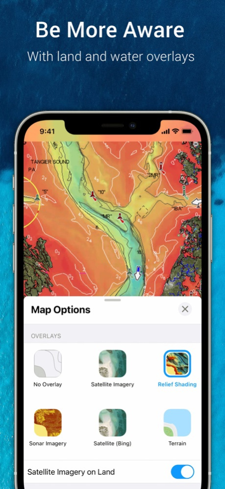
The overlays have changed:
. Discover updated and expanded relief shading with more coverage than before and improved detail with a vibrant color palette for better understanding of changes in depth at a glance.
. Satellite imagery is available as a separate overlay that you can combine with relief shading or sonar imagery.
version 19.0
posted on 2023-05-10
May 10, 2023
Version 19.0
The overlays have changed:
. Discover updated and expanded relief shading with more coverage than before and improved detail with a vibrant color palette for better understanding of changes in depth at a glance.
. Satellite imagery is available as a separate overlay that you can combine with relief shading or sonar imagery.
version 18.2.2
posted on 2023-03-30
Mar 30, 2023
Version 18.2.2
Bug fixing and optimization.
version 18.0.2
posted on 2022-07-25
Jul 25, 2022 Version 18.0.2
Auto Guidance+(TM) technology* is now available. Get underway with smoother suggested routes that consider your designated overhead clearance, distance to shoreline and more.
Be sure to configure your boat settings (draft, height and more) for best results.
*Auto Guidance+ is for planning purposes only and does not replace safe navigation operations.
version 17.2.2
posted on 2022-03-31
Mar 31, 2022 Version 17.2.2
We’ve updated our catalog! Now it’s easier to find coverage for the waters you like to explore, thanks to new and extended coverage regions. Though some coverage has been discontinued, that chart content has been more conveniently absorbed into several new and existing coverage regions. Check the catalog in Menu> Charts and Updates.
version 17.2.1
posted on 2022-03-18
Mar 18, 2022 Version 17.2.1
We’ve updated our catalog! Now it’s easier to find coverage for the waters you like to explore, thanks to new and extended coverage regions. Though some coverage has been discontinued, that chart content has been more conveniently absorbed into several new and existing coverage regions. Check the catalog in Menu> Charts and Updates.
version 17.1.1
posted on 2021-12-17
Dec 17, 2021
Version 17.1.1
- Now you can add up to 3 pictures while reviewing ActiveCaptain(R) Community POIs, such as anchorages, marinas, hazards and more. Plus, the Community POIs icons have a new color palette.
- Effective now, the app will no longer support data migration from old, discontinued apps.
version 17.1
posted on 2021-12-01
Dec 1, 2021 Version 17.1
- Now you can add up to 3 pictures while reviewing ActiveCaptain(R) Community POIs, such as anchorages, marinas, hazards and more. Plus, the Community POIs icons have a new color palette.
- Effective now, the app will no longer support data migration from old, discontinued apps.
version 17.0.2
posted on 2021-07-30
Jul 30, 2021 Version 17.0.2
- Bug fixing and optimization.
version 17.0.1
posted on 2021-07-16
Jul 16, 2021 Version 17.0.1
Our Connections feature now offers more:
- Exchange adventures and favorite places with your connections by sharing tracks, routes and markers.
- Show everyone how cool your boat or kayak is and what activities you like to do while out on the water.
- Check your friend’s Connections list to find more people you know or who have the same interests as you.
version 17.0
posted on 2021-07-14
Jul 14, 2021 Version 17.0
Our Connections feature now offers more:
- Exchange adventures and favorite places with your connections by sharing tracks, routes and markers.
- Show everyone how cool your boat or kayak is and what activities you like to do while out on the water.
- Check your friend’s Connections list to find more people you know or who have the same interests as you.
version 16.3.1
posted on 2021-06-01
Jun 1, 2021 Version 16.3.1
- Bug fixing and optimization.
version 16.3
posted on 2021-05-18
May 18, 2021 Version 16.3
- Bug fixing and optimization.
version 16.2.1
posted on 2021-05-05
May 5, 2021 Version 16.2.1
- Bug fixing and optimization.
version 16.2
posted on 2021-04-26
Apr 26, 2021 Version 16.2
- Bug fixing and optimization.
version 16.1.2
posted on 2021-04-01
Apr 1, 2021 Version 16.1.2
- Bug fixing and optimization.
version 16.1
posted on 2021-03-04
Mar 4, 2021 Version 16.1
- This is the last version that supports iOS 10.0 and 11.0. Future app versions will be available only for iOS 12.0 or higher. In case you cannot upgrade your operating system, you will still be able to use this app version.
- Discover the new sonar imagery overlay, which reveals bottom hardness clearly in a contrasting display so you can easily identify transition areas and find the best spots to cast your lure. Available on select U.S. lakes; check the list on Navionics.com/usa.
version 16.0.2
posted on 2021-02-09
Feb 9, 2021 Version 16.0.2
- Bug fixing and optimization.
version 16.0
posted on 2021-01-04
Jan 4, 2021 Version 16.0
- Connections feature is here to help you stay in touch with your friends and fellow boaters. Share your live location with them to easily meet on the water or let them check out your adventures. To start connecting now, go to Menu> Connections.
- Remember that profile picture, activities, and boat settings are synced automatically across all your devices.
version 15.6
posted on 2020-11-26
Nov 26, 2020 Version 15.6
- Bug fixing and optimization.
version 15.5
posted on 2020-10-21
Oct 21, 2020 Version 15.5
- Bug fixing and optimization.
version 15.4
posted on 2020-09-17
Sep 17, 2020 Version 15.4
- Bring your info with you: now profile picture, activities and boat settings will be synced automatically across all your devices.
- Bug fixing and optimization.
version 15.3
posted on 2020-07-29
Jul 29, 2020 Version 15.3
- Bug fixing and optimization.
version 15.2
posted on 2020-07-06
Jul 6, 2020 Version 15.2
- Spotting fish holding areas at a glance is easier than ever. Now you can combine the customizable multiple depths ranges of Fishing ranges with the unique bottom prospective of SonarChart Shading and relief shading (check coverage at navionics.com).
- Easily check point of interest detailed information without losing sight of the chart thanks to the new user interface.
version 15.1
posted on 2020-06-12
Jun 12, 2020 Version 15.1
[+] Get the NEW overlay RELIEF SHADING (currently available only in U.S., check coverage at navionics.com) for an easy-to-interpret, clearer view of bottom structure than contour lines alone. Available with an active subscription. Download it: Menu> Download Maps> +> Relief Shading. Display it: Menu> Map Options.
[+] Dashes indicating restricted areas borders now have a T shape so it’s easier to differentiate the inside of the area from the outside.
version 15.0
posted on 2020-04-16
Apr 16, 2020 Version 15.0
[+] Your maps will never look the same:
- Get the new NAVIONICS SATELLITE OVERLAY WITH SONARCHART(TM) SHADING: a unique perspective of underwater topography at a glance. Download it from Menu> Download maps> “+” > SonarChart Shading > Download. Available with an active subscription.
- Easily unfold the different chart layers-overlay combinations thanks to the new redesigned Map Option section. Go to Menu> Map Option.
[+] Route color has changed for better viewing. Goodbye blue, hello magenta.
[+] We also added some new cool marker icons.
version 14.9
posted on 2020-03-12
Mar 12, 2020 Version 14.9
[+] AIS improvements:
- Don't miss approaching targets with the new AIS COLLISION ALARM. Just connect to an AIS device: Menu> Connect a Device. To customize AIS settings, go to: Menu> Map Options> AIS Settings.
- Targets around you have stopped sending AIS signal? Now you can spot them at a glance: a red X will be placed on their icon.
[+] Now you can remove previously connected devices: go to Menu> Connect a device> Tap the gear icon associated with the device> tap Forget device
version 14.8
posted on 2020-01-20
Jan 20, 2020 Version 14.8
Now it is necessary to have an ACCOUNT. WHY?
> We recently linked the app subscription to the Navionics account. So that you can use JUST ONE SUBSCRIPTION across your devices.
> Plus, having an account will SECURE YOUR PURCHASES and SYNC YOUR CHARTS AND DATA across all your mobile devices.
Get a flawless, coherent and seamless experience.
Open the app and sign in.
version 9.2.1
posted on 2014-01-02
version 15.0
posted on 1970-01-01
2020年4月16日 Version 15.0
[+] Your maps will never look the same:
- Get the new NAVIONICS SATELLITE OVERLAY WITH SONARCHART(TM) SHADING: a unique perspective of underwater topography at a glance. Download it from Menu> Download maps> “+” > SonarChart Shading > Download. Available with an active subscription.
- Easily unfold the different chart layers-overlay combinations thanks to the new redesigned Map Option section. Go to Menu> Map Option.
[+] Route color has changed for better viewing. Goodbye blue, hello magenta.
[+] We also added some new cool marker icons.
version 15.3
posted on 1970-01-01
2020年7月29日 Version 15.3
- Bug fixing and optimization.
version 15.4
posted on 1970-01-01
17 сент. 2020 г. Version 15.4
- Bring your info with you: now profile picture, activities and boat settings will be synced automatically across all your devices.
- Bug fixing and optimization.